

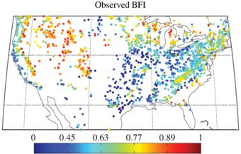
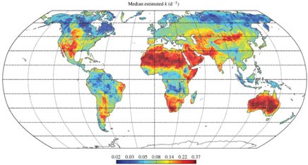
The Global Streamflow Characteristics Dataset (GSCD) comprises global maps of 17 streamflow characteristics such as mean annual streamflow and baseflow index, providing information about catchment behavior for the entire land surface including ungauged regions.
The maps are unique in the sense that they were derived using a data-driven (top down) approach based on streamflow observations from more than 7000 catchments across the globe, rather than using a physically-based (bottom up) process model.
Being based on streamflow observations, the maps capture the catchment behavior in an integral way and are not affected by incorrect or overly simplistic process representations in physically-based models.
For more details on the derivation of the maps see Beck et al., Global patterns in baseflow index and recession based on streamflow observations from 3394 catchments, Water Resources Research, DOI: 10.1002/2013WR013918.
For questions email Hylke Beck.
Download the latest version, including documentation here (145MB).